


Zagori is a mountainous area of Epirus, north of Ioannina, known for its 46 stone villages, Ottoman-era arched bridges and the Vikos Gorge. Allow three to five nights, hire a car and base yourself in Central Zagori or the Papingo villages.
Zagori is the mountain Greece that most visitors never see: 46 villages built entirely of grey stone, linked by cobbled mule paths and arched bridges, scattered across the slopes of the Pindus mountains above the Vikos Gorge. It is a place for walking, slow lunches and cool evenings by a fire, and it was inscribed as a UNESCO World Heritage cultural landscape in 2023. Plan at least three nights, bring good shoes and a car, and do not try to see it on a day trip.
Quick facts
- Where: Epirus, northwest Greece, between roughly 30 and 60 km north of Ioannina.
- Getting there: fly to Ioannina, or drive from Thessaloniki along the Egnatia motorway; from Corfu, take the ferry to Igoumenitsa and drive about an hour and a half.
- Time needed: three nights for the highlights, five or more for serious hiking.
- Best time: May and June for green slopes and wildflowers, September and October for walking weather and autumn colour.
- Getting around: a car is essential; public transport to the villages is minimal.
- Good for: hikers, couples, food lovers and anyone after cool mountain air in summer.
Understanding Zagori
The name is usually traced to Slavic words meaning “beyond the mountain”, and the area is often called the Zagorochoria, the Zagori villages. For centuries under Ottoman rule the region enjoyed a degree of self-government, and its men travelled as merchants across the Balkans and further afield, sending money home to build the mansions, churches, schools and bridges you see today. The result is a remarkably uniform architecture: houses of local limestone with slate roofs, high walls around courtyards, and paved squares shaded by huge plane trees.
Zagori divides into three parts. Central Zagori, around Monodendri, Kipi and Koukouli, has the famous bridges and the rim of the Vikos Gorge. West Zagori includes Megalo and Mikro Papingo under the cliffs of Mount Tymfi, plus Aristi and Vikos village. East Zagori, around Tsepelovo, Skamneli and Vrisochori, is wilder and less visited. Much of the area lies within the Northern Pindus National Park and the Vikos Aoos UNESCO Global Geopark.
The villages
Monodendri
Monodendri is the most visited village because it sits right on the edge of the Vikos Gorge. From the square a stone path leads down to the Monastery of Agia Paraskevi, a small fifteenth century monastery clinging to the cliff, with a narrow ledge path beyond it that looks straight down into the gorge (not for anyone with vertigo). Monodendri is also the start of the classic Vikos Gorge hike and the turn-off for the Oxya viewpoint.
Papingo
Megalo Papingo and Mikro Papingo, a few minutes apart, sit beneath the vertical grey walls of the Astraka towers. They are the most beautiful villages in Zagori and the best base for hikers. Between the two, a short walk from the road, the Ovires are a chain of natural rock pools carved by a stream, cold but irresistible on a hot day. Mikro Papingo is the start of the path to the Astraka refuge and the alpine Drakolimni, the Dragon Lake of Tymfi.
Kipi, Koukouli and the bridge villages
The area around Kipi and Koukouli holds the greatest concentration of stone bridges, and this is where most visitors come to photograph them. Koukouli is a quiet, beautifully preserved village, and Kapesovo and Vitsa nearby are worth a stop for their squares and churches.
The stone bridges
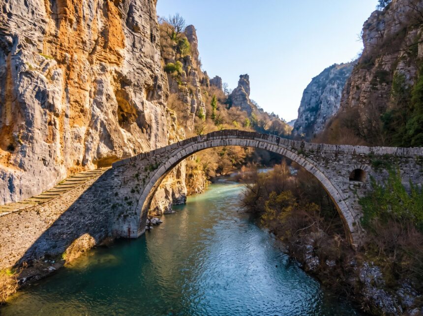
Zagori’s arched bridges were built mostly in the eighteenth and nineteenth centuries by travelling stonemasons, paid for by local benefactors so that mule trains could cross the torrents in winter. The most famous is the triple-arched Plakidas bridge, also called Kalogeriko, just outside Kipi, built in 1814 and named after the Plakidas family who later paid for its repair. Close by are the single-arched Kokkori (or Noutsos) bridge and the Kontodimos bridge, and further along the road towards Vitsa the slender Missios bridge sits in a wooded ravine. Most of the bridges are within a short walk of the road, and the well-signed paths between Kipi, Koukouli and Vitsa make a gentle half-day walk that links several of them.
The Vikos Gorge
The Vikos Gorge cuts for around 20 km through the limestone of the Pindus, with walls up to around 1,000 metres high, and it has been recognised as one of the deepest gorges in the world in relation to its width. You can enjoy it in three ways.
The viewpoints
The Oxya viewpoint, reached by a road beyond Monodendri and a short walk, looks along the deepest section of the gorge. The Beloi viewpoint, a level walk of about 20 minutes from Vradeto, the highest village in Zagori, gives the most dramatic view of all, straight down to the river bed. Go to Beloi in the morning and Oxya in the afternoon for the best light. On the way to Vradeto, look out for the Skala of Vradeto, a zigzag stone staircase that was once the only route up to the village; walking it from the bottom is a superb short hike.
Hiking the gorge
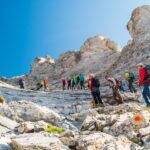
The classic hike starts in Monodendri, descends steeply into the gorge and follows the dry river bed north to the Voidomatis springs, then climbs to Vikos village or continues to Papingo. Expect around six to eight hours depending on the end point and your pace. It is a serious walk on rough ground with no services, so start early, carry plenty of water and arrange a taxi back to your car. The path is marked, but check conditions locally and do not attempt it after heavy rain or in winter without experience.

The Voidomatis river
Below the gorge the Voidomatis emerges as one of the clearest and coldest rivers in Greece. Near the old Klidonia bridge, close to Konitsa, it is used for gentle rafting and kayaking in summer, and short riverside walks lead to its emerald pools. The water stays icy even in August, so a quick dip is all most people manage.
Longer hikes
Experienced walkers come for the climb from Mikro Papingo to the Astraka refuge, at around 1,950 metres, and on to the Drakolimni, a small alpine lake below the peaks of Tymfi where alpine newts live. The refuge is roughly a three-hour climb, with another hour or so to the lake. Combined with a night at the refuge, it is one of the best mountain walks in Greece, comparable in drama if not in height to the Mount Olympus hike. Shorter marked paths link almost every village pair, often on old cobbled kalderimia, so you can walk from one village to lunch in the next and back.
Food and where to stay
Zagori is pie country. Every taverna serves Epirot pites, from wild greens and leek to cheese and cornmeal pies, along with slow-cooked lamb and goat, local trout, mountain tea and wild mushrooms in autumn. Portions are generous and lunch is the main meal.
Accommodation is almost entirely in small stone guesthouses, many in restored mansions with fireplaces and breakfasts of home-made pies and preserves. Monodendri and Kipi are central for the bridges and viewpoints; the Papingo villages are best for hikers and atmosphere; Aristi has a few upmarket hotels and quick access to the Voidomatis. Book ahead for weekends, Greek holidays and the whole of August.
Getting there and combining Zagori
Ioannina is the gateway, with a domestic airport, a lakeside old town and its own castle, and it is worth a night at the start or end of your trip. You will need a car: our guide to renting a car in Greece explains the paperwork, and the mountain roads in Zagori are paved but narrow and winding. From the Ionian, ferries cross from Corfu to Igoumenitsa, which makes Zagori an excellent mainland extension of a Corfu holiday. From the east, the Egnatia motorway brings you from Thessaloniki in around three hours.
Zagori also fits into a longer road trip through the mainland mountains: the monasteries of Meteora are around two and a half hours away via Metsovo, and the villages of Pelion offer a different, greener take on Greek mountain life further southeast.
Practical tips
- Fuel and cash: petrol stations are few inside Zagori, so fill up in Ioannina or on the main road. Most guesthouses take cards, but some tavernas prefer cash.
- Weather: it is much cooler than the coast. Pack a warm layer even in summer and expect snow in winter, when some roads need chains.
- Walking: good boots, a paper map or offline map, water and a phone charger are essential; mobile signal is patchy in the gorge.
- Timing: the Vikos hike and the Drakolimni walk are best from late May to October; in July and August, start at dawn.
- Respect the villages: these are small communities. Park outside the centres where signs ask you to, and keep to marked paths across farmland.
Zagori rewards those who stay put and walk. Three or four days of village-to-village paths, a morning at Beloi, an afternoon at the bridges of Kipi and long lunches of pie and lamb will show you a side of Greece far removed from the islands.
Frequently Asked Questions
How many days do you need in Zagori?
Three nights is the minimum to see the main villages, bridges and viewpoints. Five or more lets you hike the Vikos Gorge and walk up to the Drakolimni of Tymfi without rushing.
Which is the best village to stay in Zagori?
Monodendri and Kipi are best for the gorge viewpoints and stone bridges. Megalo and Mikro Papingo are the most atmospheric and ideal for hikers, while Aristi is convenient for the Voidomatis river.
How hard is the Vikos Gorge hike?
It is a long, demanding walk of around six to eight hours on rough terrain, with a steep descent from Monodendri and no services along the way. Fit walkers with good boots and plenty of water manage it well, but it is not a casual stroll.
How do you get to Zagori?
The nearest airport and city is Ioannina, about 30 to 60 km away. From Corfu you can take a ferry to Igoumenitsa and drive, and from Thessaloniki the Egnatia motorway takes around three hours. A car is essential.
When is the best time to visit Zagori?
May, June, September and October offer the best walking weather. Summer is pleasant compared with the coast, and winter brings snow and cosy guesthouses, though high paths become difficult.