


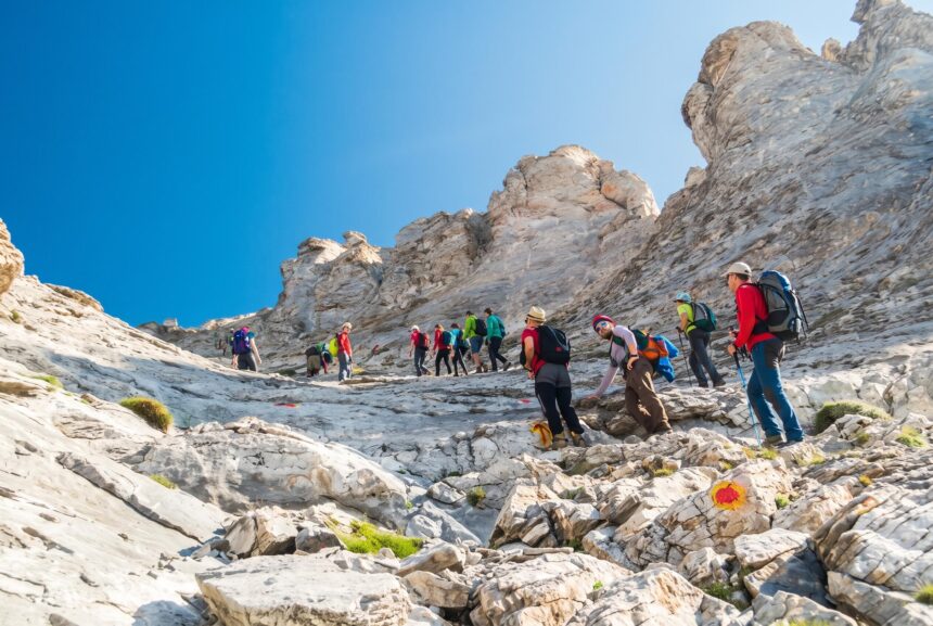
Most hikers climb Mount Olympus in two days: Prionia to the Spilios Agapitos refuge on day one, then the summit of Mytikas (2,918 m) via Louki or Kakoskala and back down on day two.
Reaching Mytikas, the 2,918-metre summit of Mount Olympus and the highest point in Greece, is a two-day hike for fit walkers with a head for heights. The usual plan is to walk from Prionia, above Litochoro, to the Spilios Agapitos refuge on day one, then climb to the summit and descend on day two. The trail is not technical until the last section, but the final scramble to Mytikas is exposed rock with real rockfall risk, so a helmet, good weather and an early start are essential.
Quick facts
- Summit: Mytikas, 2,918 metres, the highest peak in Greece.
- Trailhead: Prionia, at about 1,100 metres, 18 km by road above Litochoro.
- Time needed: two days, with a night at a refuge. Three days allows a more relaxed pace or a traverse.
- Season: roughly June to early October for a snow-free route; the main refuges open from May to late October.
- Difficulty: a demanding hike to the refuge and the summit plateau, then an exposed scramble (easy climbing) to Mytikas.
- Nearest town: Litochoro, about 90 km south of Thessaloniki.
The mountain of the gods
In Greek mythology, Olympus was the home of the twelve gods, with Zeus ruling from the summit. The massif rises straight from the coast of the Thermaic Gulf, which is why it looks so imposing from the motorway and from the beaches below. Olympus became Greece’s first national park in 1938 and is also a UNESCO Biosphere Reserve, protecting deep gorges, black pine and beech forest, and a rich alpine flora with many endemic plants.
The summit area is a crown of peaks around high cirques. Mytikas is the highest, with Stefani (the Throne of Zeus), Skolio and Skala close by. The first recorded ascent of Mytikas was on 2 August 1913, by the Swiss Fred Boissonnas and Daniel Baud-Bovy with Christos Kakalos, a hunter from Litochoro who later became the mountain’s first guide.
The standard route from Prionia
Day one: Prionia to Spilios Agapitos refuge
From the car park at Prionia, the E4 long-distance path climbs through forest to the Spilios Agapitos refuge (also called Refuge A), at around 2,100 metres. It is about 1,000 metres of ascent and usually takes 2.5 to 3 hours. The path is clear and well used, mostly shaded, with a steeper, open zigzag section near the end. Arrive by mid-afternoon, rest, and get an early night: the refuge serves meals, and staff can advise on the weather and the state of the summit routes.
If you have an extra day, you can also walk up to Prionia from Litochoro through the Enipeas gorge. It is a beautiful route along the river, past the ruins of the old monastery of Agios Dionysios, but it adds a long day and around 700 metres of extra climbing.
Day two: refuge to Mytikas and back down
Start at first light. From the refuge, the path climbs above the treeline to a junction called Zonaria, around 2,480 metres. Here you have two choices to reach the summit area:
- Via Skala and Kakoskala: the more common route continues on loose gravel to the Skala peak at 2,866 metres, the hardest walking section of the day. From Skala, the Kakoskala (the bad steps) leads along and across rock ledges to Mytikas, following red marks. Expect hands-on scrambling with big drops below.
- Via the Louki couloir: from Zonaria, a traverse leads to the foot of Louki, a steep gully that climbs about 150 metres directly to the summit. It involves easy climbing moves on polished rock and is the main rockfall zone on the mountain, especially when several groups are on it.
A common strategy is to go up the Louki couloir and down the Kakoskala, which avoids descending the loose gully. Allow around three to four hours from the refuge to the summit, depending on your route and the crowds, then a similar time back to the refuge and another two hours or more down to Prionia. It is a long day, often 10 hours or more in total.
Many walkers who are uncomfortable with exposure stop at Skala or continue to Skolio, the second-highest peak at 2,911 metres, which is a straightforward walk from Skala with fine views of Mytikas and the cliffs of Stefani. There is no shame in turning back: the view from Skala is spectacular.
Refuges on Olympus
Several staffed refuges make a summit attempt possible without camping. Sleeping places are limited, so book well ahead for July, August and weekends.
- Spilios Agapitos (Refuge A): around 2,100 metres on the main E4 route from Prionia. Open from May until the last week of October, with meals. It is the usual base for the summit.
- Giosos Apostolidis: around 2,700 metres on the Plateau of the Muses, close to the start of the summit paths. Usually staffed from June to the end of October.
- Christos Kakalos: around 2,650 metres on the edge of the Plateau of the Muses. Usually open from late May into the autumn.
- Stavros (Dimitrios Bountolas): at about 930 metres on the road from Litochoro to Prionia, useful for an early start or for families walking lower down.
Operating dates are set each year and can shift with snow conditions, so confirm directly with the refuge before you go. Outside the staffed season the refuges are closed and the mountain is a winter alpine environment.
Safety: what you need to know
- Wear a helmet for the summit: rockfall is the main hazard on Louki and the Kakoskala, often triggered by people above. Helmets can be rented at Spilios Agapitos, but confirm availability in advance or bring your own.
- Watch the weather: afternoon thunderstorms are common in summer. Aim to be off the summit by late morning, and turn back if clouds build quickly. Lightning on exposed rock is a serious danger.
- Expect cold: even on hot days in Litochoro, the summit can be windy and near freezing. Carry a warm layer, a waterproof jacket, gloves and a hat.
- Snow lingers: in May and June, snow can remain on the upper slopes and in the gullies, turning the scramble into a mountaineering route that needs crampons, an ice axe and experience.
- Carry water: there is very little water above the refuge. Fill up before leaving and carry at least two litres.
- Do not overtake in the gullies: wait your turn, warn people below if you dislodge a stone, and never descend Louki in a crowd.
- Emergencies: call 112. Mobile coverage is patchy in places, so tell the refuge your plans and expected return time.
If you are not confident on exposed rock, hire a qualified, licensed mountain guide for the summit day. The Kakoskala and Louki are short, but a slip there can be fatal.
What to pack
- Sturdy hiking boots with good grip, and trekking poles for the long descent.
- A helmet for the summit section.
- Warm and waterproof layers, a hat, gloves and sunglasses.
- Sun cream: the upper mountain is fully exposed.
- A sleeping bag liner or sleeping bag and towel for the refuge, plus light shoes for indoors, as boots stay in the entrance.
- Head torch, snacks, two litres of water and some cash.
Getting there
Litochoro is the base town, set at the foot of the mountain near the coast. It is about an hour by car from Thessaloniki and lies just off the Athens to Thessaloniki motorway; trains on the same line stop at Litochoro station, a short taxi ride from the town. From Litochoro, an asphalt road winds 18 km up to Prionia. There is no reliable public bus to the trailhead, so drive, take a taxi or arrange a transfer. Parking at Prionia fills up on summer weekends.
Many visitors combine Olympus with a city break; see our Thessaloniki travel guide for the city, and our Pelion travel guide for more mountain and beach scenery further south. Inland, the rock pinnacles of the Meteora monasteries are around two hours’ drive away.
Is the Olympus hike right for you?
If you can comfortably walk 1,000 metres of ascent in a day and do not mind steep, loose ground, you can reach the refuge and Skala. The summit itself needs confidence on exposed rock. Compare it with other big Greek hikes: the Samaria Gorge in Crete is longer but mostly downhill and non-technical, while the trails of Zagori offer gorge and village walking without summit exposure. For timing your trip, our guide to the best time to visit Greece explains the seasons across the country.
Practical tips
- Book the refuge first: then build the rest of the trip around your confirmed night.
- Go midweek: the summit gullies are less crowded, which also means less rockfall.
- Start before dawn on summit day: to finish the scramble before clouds and storms build.
- Leave a buffer day: if the weather is poor, wait rather than force the summit.
- Respect the national park: stay on marked paths, take all rubbish down and do not pick plants.
Frequently Asked Questions
How long does it take to hike Mount Olympus?
Most people take two days. Day one is Prionia to the Spilios Agapitos refuge in about 2.5 to 3 hours; day two is the summit and the descent, often 10 hours or more.
Is the Mount Olympus hike difficult?
The walk to the refuge and to Skala is demanding but non-technical. The final section to Mytikas, via Louki or the Kakoskala, is an exposed scramble with rockfall risk and needs a helmet and a head for heights.
When is the best time to hike Mount Olympus?
June to early October is the usual season for a snow-free route, with July to September the most reliable. The main refuge, Spilios Agapitos, is open from May until the last week of October.
Do I need a guide to climb Mytikas?
A guide is not required, and many experienced hikers go independently. If you have no scrambling experience or are nervous on exposed rock, hiring a licensed mountain guide for the summit day is sensible.
Can you climb Mount Olympus in one day?
Very fit and experienced mountaineers sometimes do it, but it means well over 1,800 metres of ascent and descent on loose terrain. For most people, a night at a refuge is safer and more enjoyable.